

a ![]() solution
solution
The Solution For Optimized Roadways
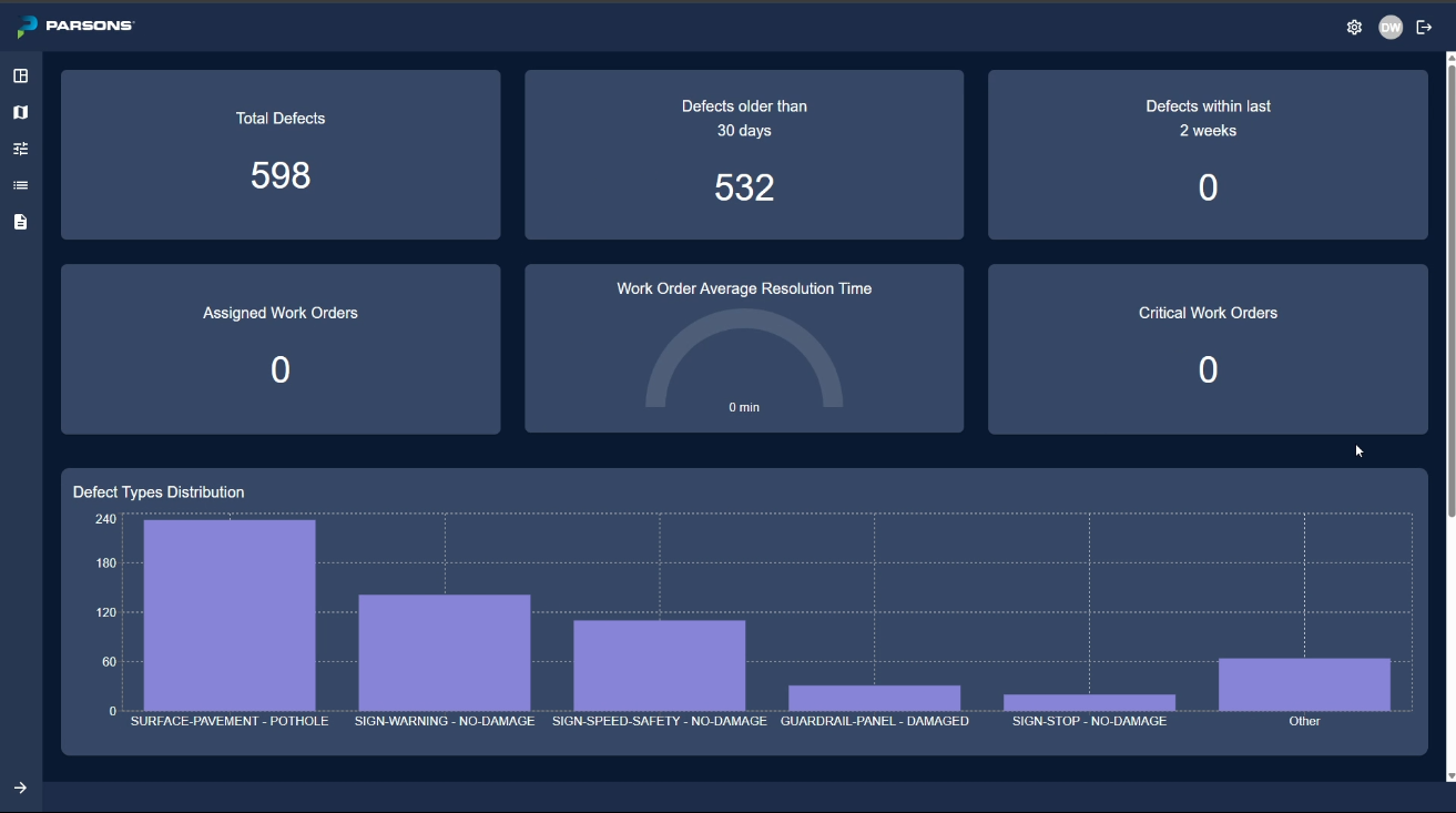
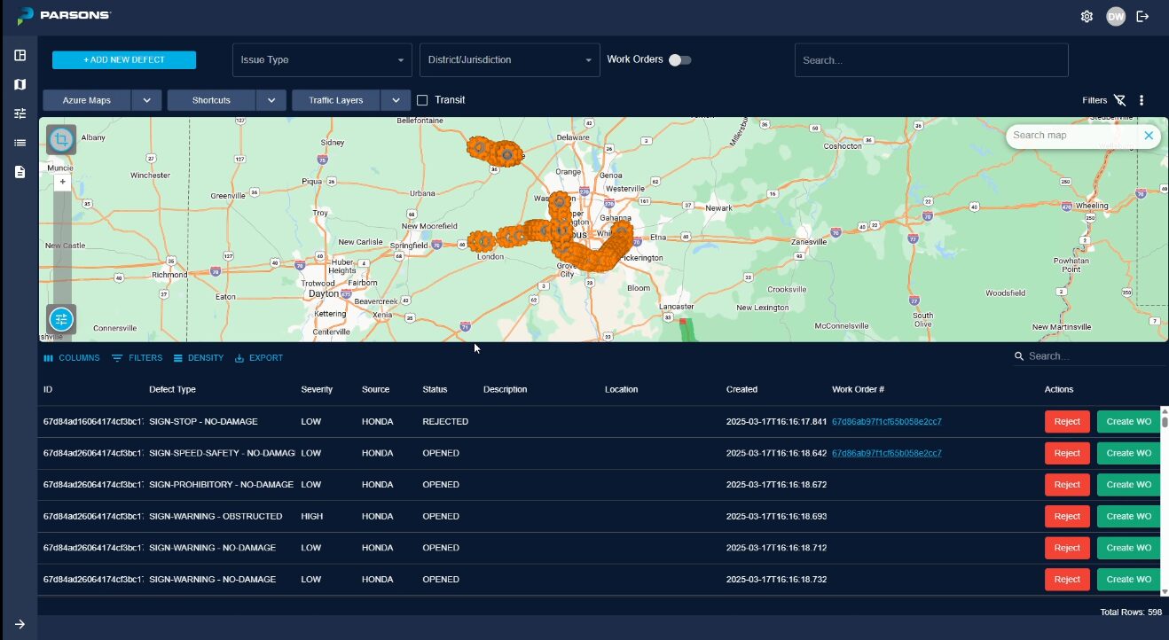
iNET Asset Guardian is a full lifecycle asset management system, integrated into Parsons’ iNET® Smart Mobility Platform, designed to streamline roadway maintenance and operations. By combining real-time data from IoT sensors, cameras, connected vehicles, and mobile devices into iNET’s single-pane-of-glass, this powerful tool leverages AI and GIS spatial technology to accurately evaluate infrastructure conditions and pinpoint defects along the right-of-way with precision.
The platform supports configurable inventory and asset tracking, automated work order generation, and proactive condition assessments to enhance operational efficiency. With a GIS mapping interface powered by Azure Base Maps, users can easily visualize and manage roadway data. Rich reporting capabilities allow exports to common formats such as PDF, Excel, and CSV, enabling seamless data sharing and compliance tracking.

Road Condition And Asset Monitoring
- Real-time inspection using vehicle-mounted cameras and OEM sensors
- AI-driven detection of surface defects, like potholes and cracks
- Integrates with multiple data sources (cameras, connected vehicles, lidar)
- Compliant with all privacy regulations

Asset Identification And Inventory
- Identification of roadway assets utilizing AI and patented computer vision technology
- Asset images and locations are categorized, cataloged, and securely stored
- Real-time inspection and reporting of asset conditions
Situational Awareness And Work Order Management
- Automated work order generation for rapid response and proactive preventive maintenance
- Real-time visibility on traffic patterns, environmental factors, and asset conditions
- Rich GIS mapping of roadway assets
- Comprehensive performance reporting and KPI tracking
Real-Time Collection
- Employs IoT sensors and mobile devices for continuous monitoring
- Monitors road conditions, traffic patterns, and environmental factors in real time to provide instant, accurate data for improved decision-making
- Enables quick identification and resolution of issues to enhance safety and efficiency in transportation systems
Automated Condition Assessment

- Utilizes machine learning algorithms for precise data analysis
- Automatically detects and categorizes road defects by severity
- Reduces manual inspection time and increases accuracy in defect identification
- Supports proactive maintenance planning for improved infrastructure management
Privacy Protection
- Redacts personal identifying information to protect individual privacy and minimize risk of data breaches
- Builds public trust through enhanced privacy regulation compliance and data security
Geospatial Mapping
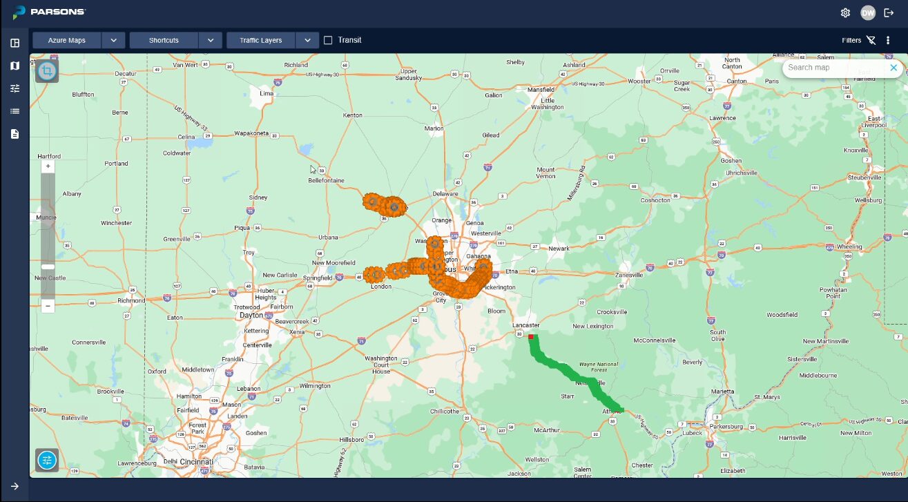
- Integrates with GIS systems for detailed mapping of road networks and assets
- Provides visual representation of road conditions and asset locations
- Enhances planning, analysis, and resource allocation through improved data visualization