Smart Mirroring for Smarter Decisions
What is a DIGITAL TWIN?
 : A Smart Mobility Solution
PSMdt is a smart mobility solution that creates digital replicas of real-world systems and seamlessly connects them with any type of equipment through the Internet of Things.
Learn More...
PSMdt is a next-generation digital twin solution purpose-built for highway infrastructure, combining advanced 3D modeling, real-time data integration, and immersive visualization to support the full lifecycle of design, analysis, and operations. It enables users to create rich virtual environments using photorealistic 3D tiles or high-fidelity LiDAR/photogrammetry models, populate them with georeferenced 2D/3D design data, and virtually place ITS equipment using a customizable library of devices. With integrated camera simulation, ray-casting-based visibility analysis, and real-time data ingestion from field systems, the platform delivers powerful tools for planning, monitoring, and decision-making. Its ability to send optimized control actions back to physical infrastructure, manage unlimited sensor metadata, and provide immersive VR experiences places it at the forefront of Industry 4.0 innovation. Furthermore, web-based sharing and collaborative access ensure seamless communication across disciplines and organizations. The platform exemplifies the convergence of digital engineering, IoT, and spatial computing — a true reflection of state-of-the-art Web 3.0 and Industry 4.0 technologies.
PSMdt seamlessly integrates real-time data from IoT devices, supports immersive virtual experiences through VR, and enables intelligent, closed-loop control of physical systems — all within a geospatially accurate digital twin environment. With support for scalable data management, open APIs, and semantic metadata structures, the platform is designed for interoperability, automation, and advanced analytics. This positions it not only as a next-generation infrastructure management tool, but as a future-ready solution that reflects the most advanced trends in decentralized connectivity, cyber-physical integration, and human-centric digital interaction.
PSMdt is equipped with a comprehensive set of features designed to meet the complex needs of modern highway infrastructure projects. From early-stage design to real-time operations and maintenance, each capability is built to enhance collaboration, accuracy, and efficiency across disciplines. The following key features illustrate how the platform leverages the latest in digital twin technology, immersive visualization, and intelligent automation to deliver a fully integrated and future-ready solution.
PSMdt is a cutting-edge smart mobility platform that transforms real-world roadways and urban spaces into interactive digital replicas. By combining high-resolution 3D environments with intelligent transportation systems and real-time data integration, it enables users to monitor, analyze, and experience mobility infrastructures like never before. Whether through immersive virtual trips, live ITS visualizations, or seamless web-based access, PSM DIGITAL TWINS brings the Internet of Things into motion – offering a powerful tool for simulation, planning, and public engagement.
Key Features of
PSMdt is an advanced digital twin platform tailored for highway infrastructure, merging 3D modeling, real-time data, immersive visualization, and intelligent automation. Designed to span the entire project lifecycle—from planning to operations—it embodies Web 3.0 and Industry 4.0 technologies for modern infrastructure management.
Virtual Environment Creation
More...
PSMdt offers advanced capabilities for generating highly detailed and accurate virtual environments of highway infrastructure. This forms the foundational layer of the digital twin. Two primary methods are supported:
- Integration with Existing Photorealistic 3D Tiles:
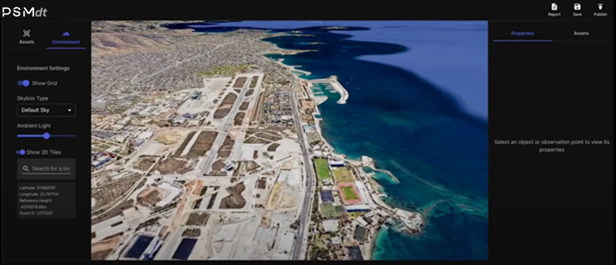 The platform can leverage Google’s high-resolution photorealistic 3D tiles (or other publicly available datasets) to quickly render virtual replicas of large-scale highway areas. This enables rapid deployment and cost-effective visualization where data coverage is available.
 - Custom 3D Model Development (LiDAR & Photogrammetry): For areas requiring higher fidelity or where existing 3D tiles are insufficient or unavailable, the platform supports the generation of detailed 3D models using LiDAR scans or photogrammetric techniques. These methods ensure precise spatial accuracy, capturing roadway geometry, elevation profiles, signage, roadside assets, and environmental features.
This dual-mode approach allows users to balance speed, cost, and precision based on their specific project needs.
Georeferenced Design Data Integration
More...
PSMdt enables the seamless integration of georeferenced design drawings into the digital twin, supporting a wide range of design disciplines and file formats. This functionality allows project stakeholders to overlay and visualize detailed 2D and 3D design information directly within the geographic context of the highway environment.
PSMdt supports:
- Multi-Disciplinary Designs: The digital twin can be populated with geospatially aligned drawings from various domains, including Electromechanical systems, Communications, Intelligent Transportation Systems (ITS), Road Construction, Drainage, and more. Each dataset is positioned accurately within the virtual environment, facilitating cross-disciplinary coordination.
- BIM and CAD Compatibility: The platform supports the ingestion of Building Information Modeling (BIM) data as well as traditional 2D and 3D CAD drawings. This ensures that both high-level conceptual plans and detailed engineering designs can be visualized and evaluated spatially.
- Geographic Project Overview: By consolidating all relevant design documents within a single, location-aware interface, the platform provides a comprehensive geographic view of the project. This enhances collaboration, reduces design conflicts, and improves communication between teams throughout the design and planning phases.
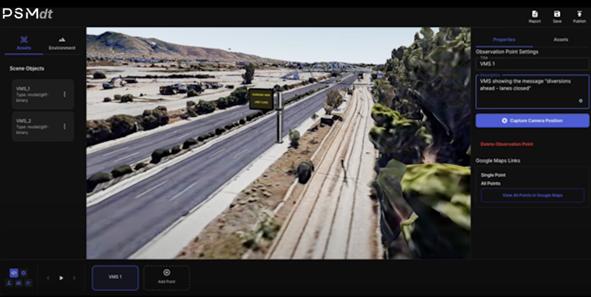
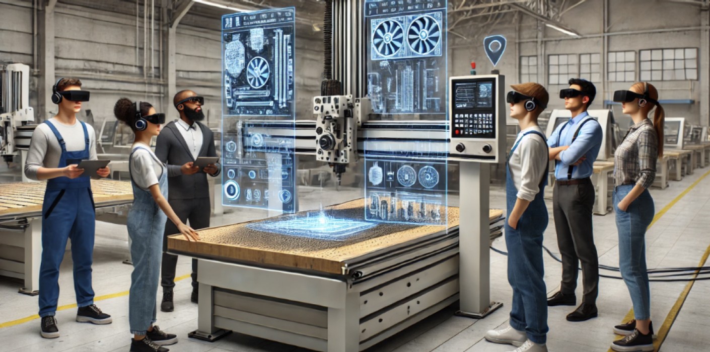
Virtual Equipment Placement (ITS Design)
More...
- Interactive Equipment Placement:
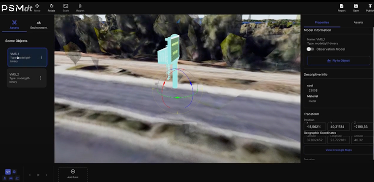 Designers and integrators can virtually navigate through the digital twin to identify optimal locations for ITS devices, such as cameras, Variable Message Signs (VMS), Variable Speed Limit Signs (VSLS), sensors, and other roadside systems. This spatially accurate interaction enhances early design validation and ensures devices are optimally positioned for performance and coverage.
 - Digital Library of 3D ITS Models: The platform includes (or allows the creation of) a comprehensive digital library of 3D models representing ITS equipment. Users can select devices from this library and place them into the environment with full control over position, orientation, and scale. This allows for accurate representation of real-world installations.
Virtual equipment placement provides stakeholders with a realistic preview of how systems will be integrated into the highway infrastructure. It supports coordination, clash detection, visibility analysis, and documentation during the design phase. This feature significantly improves the efficiency, accuracy, and collaboration in ITS planning and deployment.
Camera Simulation & Visibility Analysis
Simulates camera behavior with adjustable parameters and uses ray-casting to analyze visibility, blind spots, and field overlaps.
More...
PSMdt supports the virtual placement and configuration of surveillance or ITS cameras within the digital twin, enabling advanced visibility and coverage analysis. The following core functionalities are supported:
- Configurable Camera Parameters:
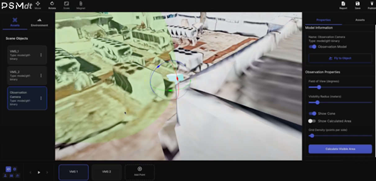 Users can position virtual cameras anywhere in the 3D environment and configure key parameters such as angle of view (field of view), detection radius, and orientation along all three rotational axes (pitch, yaw, roll). This allows for highly accurate modeling of real-world camera behavior.
 - Heat Zone & Visibility Area Calculation:
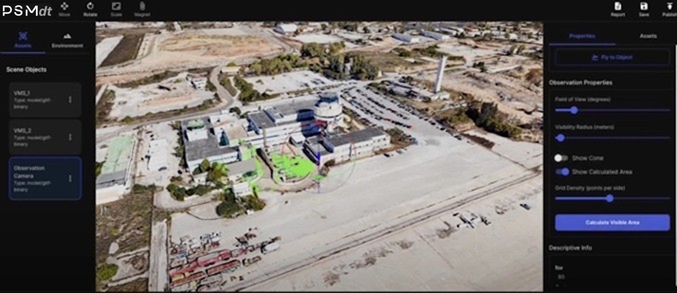 Using ray casting techniques, the platform calculates and visualizes camera coverage zones — also known as heat zones. These visual overlays highlight which areas are visible from a given camera location and orientation, supporting precise analysis of blind spots and overlapping fields of view.
This feature is essential for verifying the placement of ITS surveillance systems (e.g., CCTV, ANPR cameras) and ensuring optimal coverage with minimal redundancy. It supports security planning, incident detection layout, and operational efficiency in highway environments. By simulating and analyzing camera performance in a photorealistic, georeferenced 3D context, this tool enables data-driven decisions early in the design process.
Real-Time Data Integration with External Systems
Ingests live feeds (traffic, weather, sensors) via APIs/web services to transform the digital twin into a dynamic operations dashboard.
More...
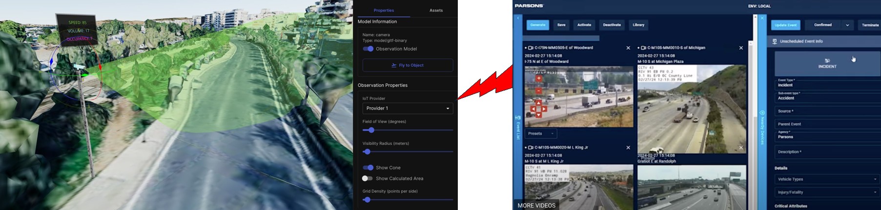
Incoming data can be dynamically visualized directly within the 3D environment — e.g., changing VMS messages, live sensor readings, or dynamic object movements — providing operators and designers with a powerful, intuitive interface for situational awareness.
PSMdt is flexible in terms of connectivity with external systems. 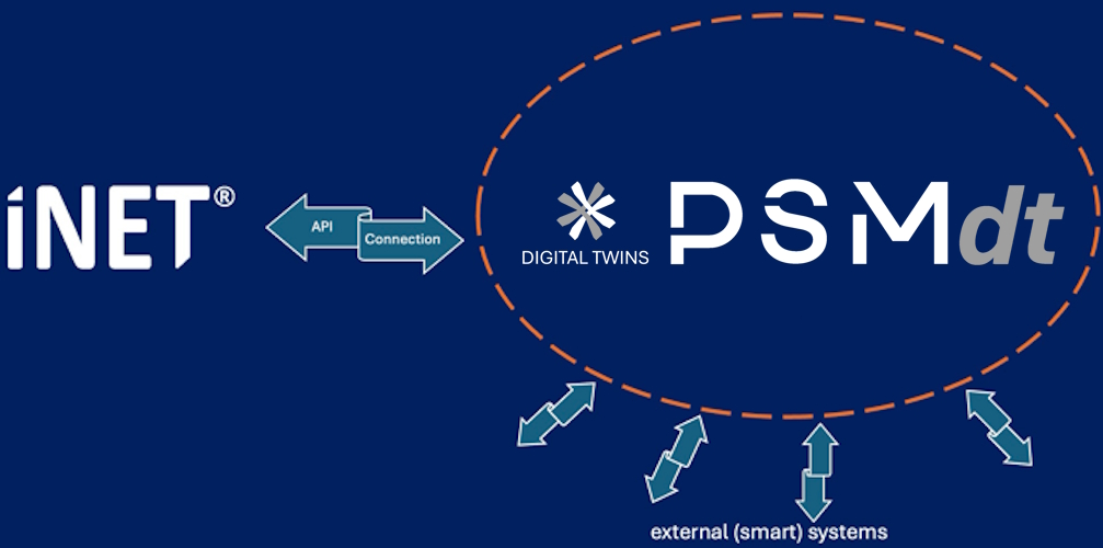 Integration is enabled through standard protocols such as RESTful APIs, WebSocket connections, or web services, ensuring interoperability with various third-party platforms, SCADA systems, traffic management centers, or data aggregators.
Use Cases with Real-time feeds can be used for a wide range of applications, such as, live traffic flow visualization, incident detection and response, environmental condition monitoring, equipment status and fault detection, smart maintenance triggers etc.
This feature ensures that the digital twin serves not only as a design and planning tool, but also as a real-time digital operations dashboard.
Bidirectional Communication & Optimized Control Actions
Sends intelligent control actions back to physical infrastructure (e.g., dynamic VMS or tunnel ventilation), enabling closed-loop automation.
More...
PSMdt is built on an open, modular, and scalable architecture, thus being fully customizable to support bidirectional communication with external systems, enabling automated, optimized control actions in real time. Whether interfacing with traffic management systems, tunnel SCADA, smart lighting, or other ITS platforms, the platform’s flexible API framework and standards-based connectivity ensure seamless integration with a wide range of third-party solutions. Its modular design allows control logic, decision rules, and optimization algorithms to be tailored to specific use cases — from dynamic VMS control to ventilation system automation. This level of customization transforms the digital twin from a passive monitoring tool into an active, intelligent agent, capable of influencing the physical environment for improved safety, efficiency, and performance. The platform supports customized, intelligent control outputs back to the physical system, enabling closed-loop interactions between the digital twin and real-world infrastructure.
This feature transforms the digital twin from a passive mirror into an active, decision-support and automation engine, closing the loop between data, intelligence, and action.
Scalable Data & Metadata Management
More...

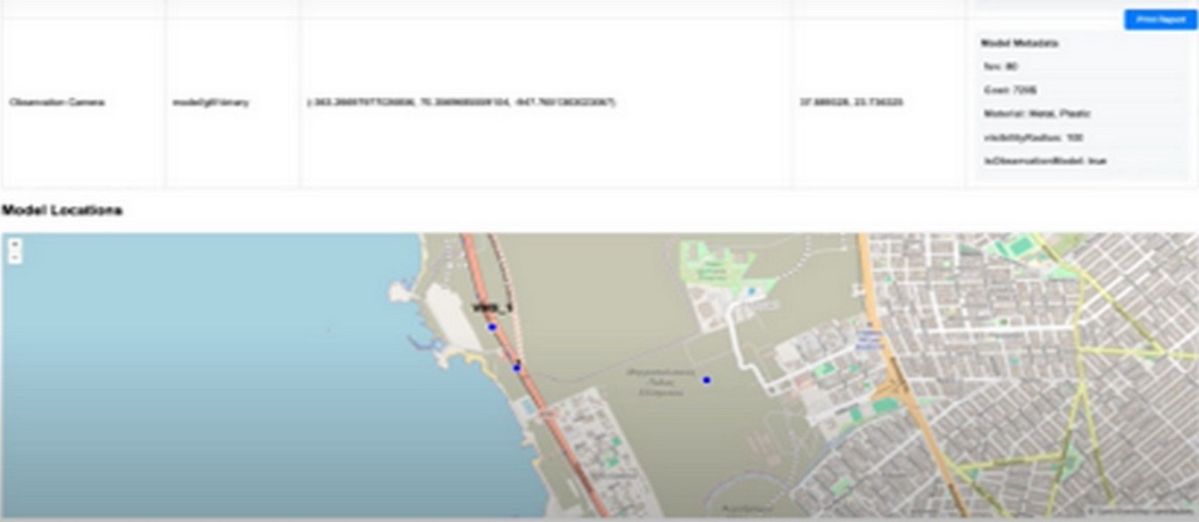
By linking all data and metadata to georeferenced, visually represented assets within the 3D environment, this feature ensures both data depth and spatial awareness across the entire infrastructure lifecycle.
Immersive VR Experiences
More...
PSMdt supports immersive experiences through Virtual Reality (VR), allowing users to engage with the digital twin in a fully immersive 3D environment — from anywhere in the world. 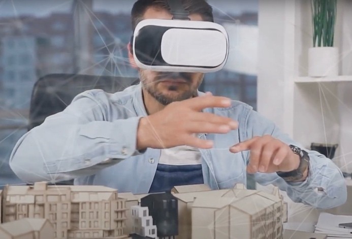 The digital twin environment can be experienced using mainstream VR devices such as Meta Quest, enabling users to virtually walk through highways, tunnels, control rooms, or construction zones before they are physically built or modified. This capability is particularly valuable during planning and construction phases, where designers, engineers, stakeholders, and clients can explore and validate infrastructure layouts, safety zones, equipment placements, and access routes — all without needing to be on-site. Immersive visualization helps bridge communication gaps between technical and non-technical stakeholders by providing a shared, intuitive understanding of complex spatial environments.
By bringing the digital twin into VR, the platform offers a powerful tool for experiential insight, supporting better decisions, fewer change orders, and greater stakeholder confidence — all before a single shovel hits the ground.
Web-Based Sharing & Collaboration
Enables secure, browser-based sharing of configured digital twin views for transparent, role-based access and decision-making.
More...
PSMdt enables secure, web-based sharing of digital twin content, supporting seamless collaboration among stakeholders, designers, engineers, and decision-makers — regardless of their physical location. Users can define specific observation points, viewpoints, or scene configurations (e.g., camera placements, ITS device layouts, study excerpts), and share them with others for focused review and discussion. Content can be shared selectively, allowing administrators to grant access to specific segments of the digital twin — such as a tunnel system, interchanges, or a particular ITS study area — based on user roles and project requirements. Shared views are accessible directly via a web browser, eliminating the need for collaborators to install or configure additional software. This makes it easy for external stakeholders or non-technical users to engage with the project in a meaningful way.
This feature supports transparent, collaborative, and efficient decision-making, accelerating project timelines and improving cross-disciplinary communication.
What is a DIGITAL TWIN?
 A digital twin functions as a high-fidelity virtual model of a physical asset, system, or process, dynamically replicating its behavior and state through the integration of advanced computational technologies. It operates in real time by synthesizing data streams and computational logic, enabling continuous monitoring, simulation, and optimization. Foundational components typically include Internet of Things (IoT) infrastructure for real-time telemetry acquisition via distributed sensor networks; Artificial Intelligence (AI) and Machine Learning (ML) algorithms for multivariate data analytics, anomaly detection, predictive modeling, and control optimization; and Augmented/Virtual Reality (AR/VR) interfaces for enhanced visualization, situational awareness, and human-machine interaction.
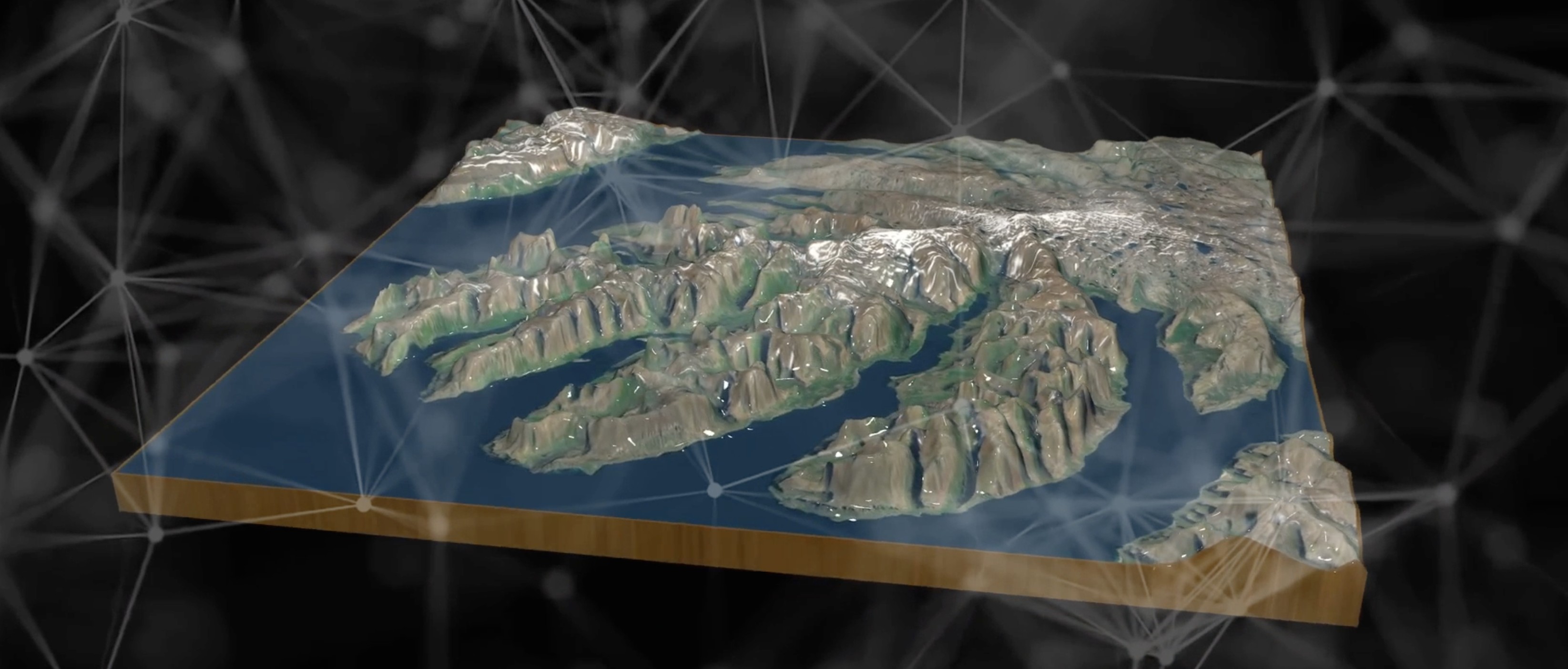 Geospatial technologies play a pivotal role not only in the creation of digital twins—leveraging advanced mapping methodologies such as photogrammetry and LiDAR—but also in augmenting their functional depth, especially where geospatial context, environmental variables, or location-specific datasets are critical. Cutting-edge advancements are increasingly being applied across a broad spectrum of domains, including smart cities and intelligent transportation systems, cultural heritage digitization, tourism analytics, construction and architectural modeling, urban and regional planning, real estate visualization, immersive training and educational platforms, interactive recreation and serious gaming, as well as the development of synthetic digital environments in the context of the metaverse.